



Innovative pilot project combined Earth Observation data, analytics derived from satellite imagery and weather forecasting to explore how flooding and vegetation risks could be identified earlier to improve inspection and decision-support.
LONDON, Aug. 10, 2026 /PRNewswire/ -- Network Rail, the owner and operator of Britain's railway infrastructure, and CATALYST (PCI Geomatics), a specialist in Earth Observation analytics, have completed an exploratory Pilot project that used satellite imagery, InSAR analytics and meteorological forecasting to investigate how weather-driven risks to rail infrastructure across the Wessex Route could be identified prior to an event.
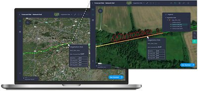
The 12-week Pilot involved collaboration between Network Rail's Wessex Route Operations and Resilience teams and CATALYST. The exploratory work produced a prototype for an Earth Observation [EO]-enabled decision-support solution that combines satellite-derived risk indicators with short-range weather forecasts. The solution explored how to provide visibility to respond to potential flooding and vegetation risk on a route up to three (3) days in advance of the forecasted weather.
Background
Britain's rail network is increasingly exposed to climate-driven hazards. Extreme heat, prolonged rainfall and changing vegetation conditions are placing growing pressure on tracks, embankments and cuttings. This is particularly acute in regions where clay-rich geology, dense vegetation corridors and exposure to summer extremes combine to create a uniquely challenging operating environment.
The Project
The Pilot brought together Network Rail's operational expertise on the Wessex Route, which spans the major commuter area of south-west London, with CATALYST's advanced Earth Observation capabilities. The result is a prototype that fuses satellite optical and radar imagery and meteorological datasets to generate location-specific risk forecasts for three hazard classes: ground deformation, vegetation fall-in, and flooding.
The solution uses a two-part framework that distinguishes between persistent susceptibility and short-term weather-driven amplification. A baseline analysis quantifies the underlying vulnerability of each rail segment using 3-year archives of satellite imagery, LiDAR-derived vegetation height models and national flood and terrain datasets. A forecast layer then applies up to 3 days of meteorological forecasting (including cumulative rainfall, peak rainfall intensity and wind gusts) to highlight where conditions are likely to elevate risk on a given day.
The solution also incorporated an interactive web-based dashboard with intuitive traffic-light classification, to produce results refreshed daily across three rail segments along the Wessex Route.
Benefits
Satellite-derived risk forecasts have the potential to materially improve the way Rail Operators anticipates and respond to weather-driven disruption. In the Pilot, the prototype highlighted locations where flooding or vegetation risks could be elevated. Subject to further development and validation, these insights could complement existing inspection planning and resource prioritisation. The Pilot also explored when conditions deteriorate, information that could help route teams make more informed operational decisions, for example on routing, speed restrictions and vegetation clearance.
Early feedback from Network Rail operational users on the Wessex Route confirmed that the outputs were broadly consistent with known risk areas, with tree fall risk noted as a potentially valuable insight. Where vegetation assessments currently occur only every three years, a satellite-enabled approach could allow for more frequent, evidence-based monitoring, with the potential to support, supporting earlier identification of high-risk corridors and more efficient deployment of vegetation teams.
By demonstrating the methodology on one of Network Rail's most climate-sensitive regions, the prototype could be scaled for Rail Operators on a network wide basis, adding additional hazard classes such as wildfire risk and autumn leaf-fall adhesion.
Quotes
"Network Rail supports the continued development of space-enabled technologies as part of a wider, complementary toolset for infrastructure risk management. This pilot has explored how satellite-derived datasets and weather information could give operational teams an earlier view of potential vegetation and flooding risks. We look forward to seeing how this type of capability continues to mature across the Earth Observation industry, with the potential to support more targeted inspections and interventions, reduce avoidable disruption, and continue to build resilience on climate-sensitive routes "Thomas Desmond, Operations Director, Network Rail
"Rail infrastructure operates at the intersection of geology, vegetation and weather, and that is exactly where Earth Observation excels. By combining InSAR data, vegetation modelling and flood susceptibility data with short-range weather forecasts, we can provide richer, more timely insight: not just where the risk is, but how it is changing day to day. This Pilot is an important step towards demonstrating the potential of satellite analytics to support Rail Operators risk mitigation efforts.June McAlarey, President & CEO, CATALYST (a PCI Geomatics brand)
Notes to Editors
About Network Rail Network Rail owns, operates, maintains and develops the railway infrastructure in England, Scotland and Wales, including 20,000 miles of track, 30,000 bridges, tunnels and viaducts, and thousands of signals, level crossings and stations. Network Rail's purpose is to connect people and goods with where they need to be, supporting the UK's economic prosperity and contributing to the objectives of the UK and Scottish Governments. Its role is to run a safe, reliable and efficient rail network and to deliver a simpler, better, greener railway for customers and communities.
About CATALYSTCATALYST, a PCI Geomatics enterprise, delivers scalable business solutions using the power of Earth Observation data and AI-enabled analytics. With over 40 years of experience in image processing and data integration, CATALYST works with space agencies, satellite providers and commercial clients worldwide. CATALYST is the first commercial entity to offer CEOS-compliant analysis-ready data for both SAR and optical satellite imagery.
Media Contacts
CATALYST / PCI Geomatics: June McAlarey, mcalarey@catalyst.earth
View original content to download multimedia:https://www.prnewswire.co.uk/news-releases/network-rail-and-catalyst-complete-exploratory-pilot-of-satellite-enabled-risk-insights-on-the-wessex-route-302846362.html
Copyright 2026 PR Newswire. All Rights Reserved.
Comunicato stampa - contenuto promozionale
Responsabilità editoriale PrNewswire.